Kevin Cheung
Results-driven computer science graduate with a master's in software engineering. Proficient in Java, C++, Python, web development, and database management. Experienced in applying machine learning techniques using remote sensing technology and web technologies. Quick learner with a commitment to continuous learning and development. Excited about challenging projects that align with expertise to foster growth and innovation.
Experience
Customer service
Responsible for efficiently managing customer orders and ensuring seamless front of house operations. Proactively addressed customer inquiries and concerns, adeptly resolving issues to maintain high levels of customer satisfaction. Leveraged bilingual proficiency in Cantonese and Mandarin to effectively communicate and fulfil additional customer requests, facilitating smooth coordination with kitchen staff.
Education
Swansea University
Achieved: Distinction
Swansea University
Achieved: 2:2
Projects
Spectral Satellite Image Analysis for Crop Classification
Conducted an extensive literature review of applications of deep learning in agricultural monitoring and formulated a comphrehensive project around crop detection using remote sensing data and deep learning. Executed image preprocessing techniques, including augmentation and transformations, to optimise remote sensing dataset obtained by Sentinel-2 satellites. Utilised PyTorch to develop a robust model that leverages both spatial and temporal dimensions for improved accuracy and successfully implemented multiclass and binary crop classification to achieve accuracies over 90%. Using the results of the crop classification, experiments were conducted with varying the time series length to provide valuable insights into the model's performance throughout different stages of the crop growth cycle, an area not previously explored. The results of this projet demonstrates a potential application of deep learning in improving global food security by crop types and subsequently the yields ahead of its harvest.
Lattice Boltzmann Fluid Simulation
Developed a comprehensive fluid dynamics simulation leveraging the lattice Boltzmann method (LBM) to model and visualize vorticity fields around cylindrical obstacles in a two-dimensional grid. Conducted initialization with default density and perturbations to accurately simulate initial fluid conditions. Implemented collision and streaming algorithms to iteratively update distribution functions, incorporating reflective boundary conditions to realistically model the interaction with obstacles. Utilized OpenCV for real-time visualization and image processing, enabling dynamic observation of the vorticity field evolution. This project, executed in C++, underscores my proficiency in numerical simulation and advanced programming, demonstrating a sophisticated application of computational fluid dynamics (CFD). The results of this simulation provide valuable insights into fluid behavior, emphasizing my ability to integrate complex mathematical models with efficient programming techniques.

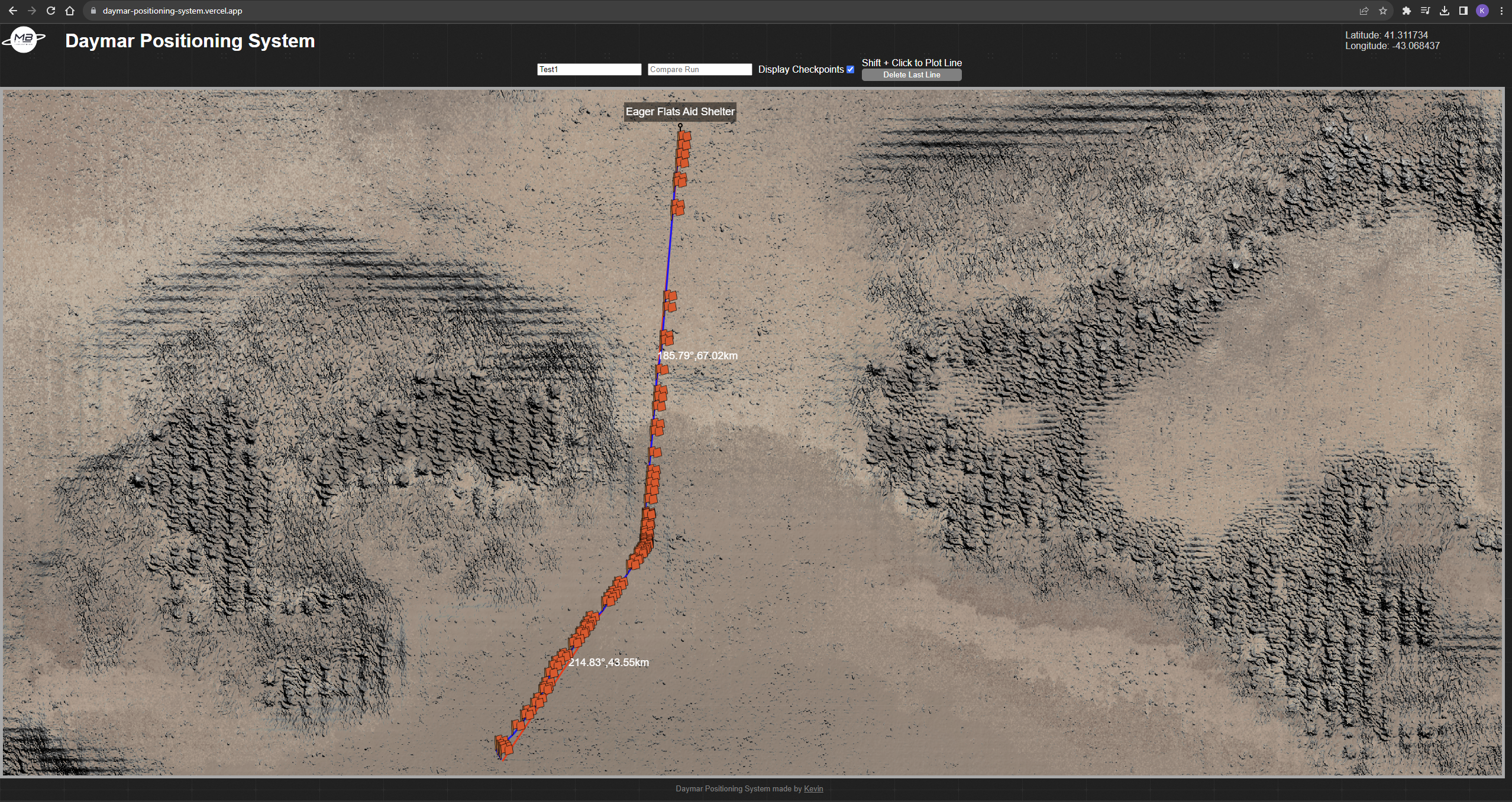
Synchronised Navigation System
Navigation tool, designed for route plotting during an endurance rally, within the game Star Citizen by Cloud Imperium Games. 3D coordinates are logged in game using a standalone client to collect and send the data to a Django backend server. These coordinates represent the player's location within a star system and are calculated to consider the planet's position in orbit around the star, the moon's position around the planet's orbit, and the rotation of the moon around its axis to determine the player's latitude and longitude on a specific moon. The map data was collected by data mining the game data files to obtain a surface and height map which was use to hillshade and accentuate elevations across its surface. The blended data is converted to XYZ tiles to divide the map into a grid of small squares at various zoom levels and displayed using Leaflet.js for efficient loading and rendering of map data.
Skills
- Java, Python, C++, JavaScript, TypeScript, HTML, CSS
- ReactJS, NodeJS, Django
- Git, GitHub, Firebase, Unix Shell
- MariaDB, MongoDB
- PyTorch